Call for Abstracts: Academic Track
Academic Track
This year’s State of the Map conference, a hybrid conference taking place in Florence and online simultaneously, will feature the fifth edition of the Academic Track - a full day of sessions dedicated to academic research about, and with, OpenStreetMap (see the last year’s Academic Track). The goal of the Track is to showcase the research and innovation of scientific investigations into OpenStreetMap while at the same time providing a bridge to connect members of the OpenStreetMap community and the academic community through an open passage to exchange ideas and opportunities for increased collaboration. We expect empirical, methodological, conceptual, or literature-review-based contributions addressing any scientific aspect related to OpenStreetMap, in particular, but not limited to, the following:
- Extrinsic or intrinsic quality assessment of OpenStreetMap data
- Analysis of contribution patterns in OpenStreetMap
- Generation of new and scientifically valuable datasets from OpenStreetMap
- Assessments of data import procedures and their impacts on data and community
- Integration between OpenStreetMap and other data sources (authoritative, user-generated, or otherwise valuable to OpenStreetMap)
- Analysis/comparison of available software for scientific purposes related to OpenStreetMap
- Novel approaches to facilitate or improve data collection and/or data quality in OpenStreetMap (e.g. through gamification or citizen science approaches)
- Artificial Intelligence / Machine Learning from, and with OpenStreetMap (e.g. AI-assisted mapping)
- Open research problems in OpenStreetMap and challenges for the scientific community
- Cultural, political, and organizational aspects of data production and usage practices in OpenStreetMap
- Studies using OpenStreetMap data in scientific domains
- Reviews of any scientific aspect connected to OpenStreetMap
In an effort to improve the interaction and collaboration between the academic and the more general OpenStreetMap communities, authors are invited to particularly highlight the practical implications or impacts of their research on the OpenStreetMap community at large.
Submission Guidelines
Authors are invited to submit extended abstracts using the State of the Map 2022 Pretalx submission system. Deadline for submission is 22 May 2022.
Abstracts should be between 800 and 1200 words. These limits will be strictly enforced for a fair and balanced review process.
Abstracts must be scientifically rigorous and the content should be logically structured as follows (without the need to include subsections): introduction/background, where the problem addressed is introduced; main aim or purpose of the study; brief description of the methodology and findings achieved; final discussion highlighting the scientific contribution of the study and its practical benefits/implications.
In the evaluation of proposals, the scientific committee will pay attention to the reproducibility of the research (where this is applicable). Reproducibility is ensured when the research makes all artifacts (input data, computational steps, methods and code) openly available to obtain consistent results. When available, the code shall be released under an open source license.
Abstracts are to be submitted online in plain-text format (no images or figures).
Abstracts will be evaluated by the scientific committee. Authors of selected abstracts will be invited to deliver an oral presentation during the Academic Track sessions at the conference or to present a poster (in case a poster session will be organised). Building on top of the successful Proceedings of the Academic Track at State of the Map 2019, State of the Map 2020, and State of the Map 2021, selected abstracts will be published as a collection, each with a distinct Digital Object Identifier (DOI) in Zenodo, an open access online repository.
The 2019 and 2020 Academic Track resulted in a special issue of the ISPRS International Journal of Geo-Information. Similarly, the scientific committee may seek to further disseminate the contributions to this conference by investigating the organization of a special issue in a relevant, open access, scientific journal. In such a case, authors of the selected abstracts will be invited to submit a full paper to this special issue. Successful submissions may benefit from partial or full waiver of publication fees.
Timeline and Deadlines
- 25 April 2022: Deadline non-academic talk submissions
1022 May 2022: Deadline academic talk submissions- 19-21 August 2022: State of the Map 2022
Submit your presentation
Please submit your presentation proposal to our submission form.
Scientific Committee
You can reach the academic track committee via email to academic-sotm@openstreetmap.org.
-
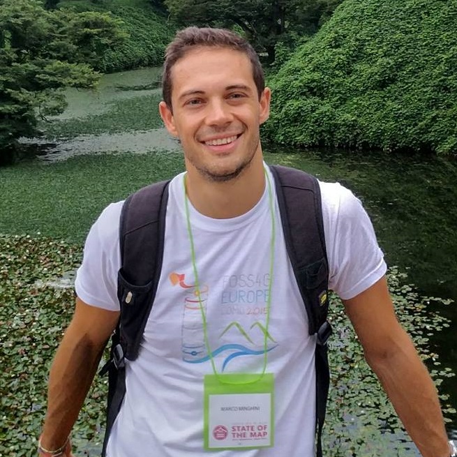 Dr. Marco Minghini –
European Commission Joint Research Centre, Ispra, Italy. (Co-chair)
Dr. Marco Minghini –
European Commission Joint Research Centre, Ispra, Italy. (Co-chair)Marco studied at Politecnico di Milano, where he got a PhD in GIS in 2014. After working as a Postdoc in the GIS group of GEOlab at Politecnico di Milano, in 2018 he joined the European Commission - Joint Research Center (JRC) in Ispra, Italy (Unit B.6 Digital Economy) as a Scientific Project Officer, making applied research on geodata interoperability and helping with the implementation of the INSPIRE Directive. Marco is an advocate of open source software and open data and has a long experience in OSM both as a contributor and as a researcher. He is a Charter Member of OSGeo, Secretary of ISPRS WG IV/4 “Collaborative Crowdsourced Cloud Mapping (C3M)”, Member of the OpenStreetMap Foundation and Voting Member of the Humanitarian OpenStreetMap Team.
-
 Dr. A. Yair Grinberger –
Department of Geography, The Hebrew University of Jerusalem, Israel (Co-chair)
Dr. A. Yair Grinberger –
Department of Geography, The Hebrew University of Jerusalem, Israel (Co-chair)Yair earned his PhD in Geography from the Hebrew University of Jerusalem, studying human mobility behaviors using GPS traces. During his postdoctoral research at the GIScience Research Group in Heidelberg University, Germany he focused on large-scale data production events in OpenStreetMap and their effects. In his current research Yair studies, among other issues, the co-construction of mapping practices and data outputs. His broader research interests include Geographic Information Science, critical GIS, and digital representations of cultural and social phenomena and issues.
-
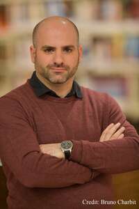
 Dr. Levente Juhász –
GIS Center, Florida International University, Miami, FL, USA
Dr. Levente Juhász –
GIS Center, Florida International University, Miami, FL, USALevente is a Research Faculty at the GIS Center at Florida International University in Miami, FL where he also serves as an adjunct professor for the Department of Earth and Environment. He has held visiting appointments at the Joint Research Centre of the European Commission in Ispra, Italy, and at the Carinthia University of Applied Sciences in Villach, Austria. In his main role at Florida International University, he oversees applied research projects within the geospatial domain. Originally trained as a geographer, he earned his PhD in Geomatics from the University of Florida. His research focuses on answering social, economical and environmental questions with data-driven approaches, and he is particularly interested in increasing our understanding of the nature of user-generated geodata. He is an avid open source and open data advocate and contributes to OpenStreetMap in many ways beyond his research. In his free time, he often maps his native country, Hungary, as well as South Florida.
-
 Dr. Pengyuan Liu –
Urban Analytics Lab, Department of Architecture, National University of Singapore, Singapore
Dr. Pengyuan Liu –
Urban Analytics Lab, Department of Architecture, National University of Singapore, SingaporePengyuan is currently working as a Postdoctoral Research Fellow at the Urban Analytics Lab, National University of Singapore. He earned his PhD in Geography from the University of Leicester (United Kingdom), researching and developing GeoAI applications in Quantitative Digital Geography. In his current research, he focuses on the studies of GeoAI applications in Urban Digital Twins, leveraging volunteered geographic information. His research interests broadly cover GeoAI, Quantitative Digital Geography, Social Sensing, Geodemographic Analysis, and Urban Complexities. He is interested in bridging geospatial analytics, artificial intelligence and social sensing in urban studies by exploring theories, algorithms and models.
-
 Hao Li –
GIScience Research Group, Heidelberg University, Germany
Hao Li –
GIScience Research Group, Heidelberg University, GermanyHao is currently a Research Associate & PhD student at the GIScience Research Group at Heidelberg University, Germany. His background includes GIS & Computer Science (BSc) and Geomatics engineering (MSc). In his current research, he focuses on deep learning from Volunteered Geographic Information (VGI) to fill sustainable data gaps in OSM and to support humanitarian mapping activities, especially in the Global South. At Heidelberg University, he gives courses on ML for geographic applications and geographical analysis of social media data. He works closely with interdisciplinary researchers from both academic and industry in a broad range of OSM-related projects.
The SotM 2022 Scientific Committee